


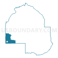
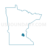
Minnetrista P-2, Hennepin County, Minnesota
About
Outline

Summary
| Unique Area Identifier | 602458 |
| Name | Minnetrista P-2 |
| County | Hennepin County |
| State | Minnesota |
| Area (square miles) | 22.52 |
| Land Area (square miles) | 18.19 |
| Water Area (square miles) | 4.33 |
| % of Land Area | 80.77 |
| % of Water Area | 19.23 |
| Latitude of the Internal Point | 44.92533540 |
| Longtitude of the Internal Point | -93.72711660 |
Maps

Graphs
Select a template below for downloading or customizing gragh for Minnetrista P-2, Hennepin County, Minnesota


Neighbors
Neighoring Voting District (by Name) Neighboring Voting District on the Map
- Franklin Twp. Voting District, Wright County, MN
- Independence P-1, Hennepin County, MN
- Laketown Twp. Voting District, Carver County, MN
- Minnetrista P-1, Hennepin County, MN
- Mound P-1, Hennepin County, MN
- Mound P-3, Hennepin County, MN
- Mound P-5, Hennepin County, MN
- Shorewood P-1, Hennepin County, MN
- St. Bonifacius P-1, Hennepin County, MN
- Victoria P-1, Carver County, MN
- Waconia Twp. Voting District, Carver County, MN
- Watertown Twp. Voting District, Carver County, MN
Top 10 Neighboring County Subdivision (by Population) Neighboring County Subdivision on the Map
- Mound city, Hennepin County, MN (9,052)
- Victoria city, Carver County, MN (7,345)
- Shorewood city, Hennepin County, MN (7,307)
- Minnetrista city, Hennepin County, MN (6,384)
- Independence city, Hennepin County, MN (3,504)
- Franklin township, Wright County, MN (2,760)
- St. Bonifacius city, Hennepin County, MN (2,283)
- Laketown township, Carver County, MN (2,243)
- Waconia township, Carver County, MN (1,228)
- Watertown township, Carver County, MN (1,204)
Top 10 Neighboring Place (by Population) Neighboring Place on the Map
- Mound city, MN (9,052)
- Victoria city, MN (7,345)
- Shorewood city, MN (7,307)
- Minnetrista city, MN (6,384)
- Independence city, MN (3,504)
- St. Bonifacius city, MN (2,283)
Top 10 Neighboring Unified School District (by Population) Neighboring Unified School District on the Map
- Eastern Carver County District 112 Public Schools, MN (51,662)
- Minnetonka Public School District, MN (39,984)
- Waconia Public School District, MN (19,242)
- Westonka Public School District, MN (17,780)
- Delano Public School District, MN (10,937)
- Watertown-Mayer Public School District, MN (9,461)
Top 10 Neighboring State Legislative District Lower Chamber (by Population) Neighboring State Legislative District Lower Chamber on the Map
- State House District 19B, MN (59,068)
- State House District 34A, MN (47,533)
- State House District 33A, MN (39,836)
- State House District 33B, MN (35,276)
Top 10 Neighboring State Legislative District Upper Chamber (by Population) Neighboring State Legislative District Upper Chamber on the Map
- State Senate District 19, MN (106,452)
- State Senate District 34, MN (94,255)
- State Senate District 33, MN (75,112)
Top 10 Neighboring 111th Congressional District (by Population) Neighboring 111th Congressional District on the Map
- Congressional District 6, MN (759,478)
- Congressional District 2, MN (732,515)
- Congressional District 3, MN (650,185)
Top 10 Neighboring Census Tract (by Population) Neighboring Census Tract on the Map
- Census Tract 277, Hennepin County, MN (8,667)
- Census Tract 1010, Wright County, MN (8,224)
- Census Tract 903.01, Carver County, MN (6,748)
- Census Tract 901, Carver County, MN (5,507)
- Census Tract 904.02, Carver County, MN (5,481)
- Census Tract 276.02, Hennepin County, MN (5,297)
- Census Tract 270.02, Hennepin County, MN (5,272)
- Census Tract 904.01, Carver County, MN (4,545)
- Census Tract 275.03, Hennepin County, MN (4,079)
Top 10 Neighboring 5-Digit ZIP Code Tabulation Area (by Population) Neighboring 5-Digit ZIP Code Tabulation Area on the Map
- 55331, MN (17,524)
- 55364, MN (14,353)
- 55387, MN (12,249)
- 55328, MN (8,541)
- 55386, MN (6,330)
- 55359, MN (5,954)
- 55388, MN (5,619)
- 55375, MN (4,518)